


Polaris GPS Navigation

Polaris GPS Navigation介绍
使用 Polaris Navigation GPS,将您的手机变成一个强大的 GPS 导航系统,最准确的通用 GPS,敢于去没有路的地方。
想象一下……仅使用手机的 GPS 定位功能和天空视野在任何水道中航行或在任何荒野或城市徒步旅行会是什么感觉?在不需要互联网连接的情况下创建导航目的地并使用离线地图或航路点指向箭头找到它们会是什么样子。
当您安装 Polaris Navigation GPS 时,这只是您手中掌握的导航能力的一瞥。
Polaris 主要用作远足、越野、航海和越野 GPS 应用程序,是您专用 GPS 卫星导航装置的出色备份或替代品,无论您去哪里进行户外探险,它都能让您保持方向!
典型用法:
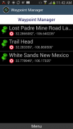
● 航点导航。
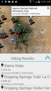
● 最好的远足地图远足GPS!搜索并找到附近的小径。
● 野外探险和户外探险。
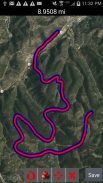
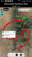
● 记录轨迹和导航轨迹。
● 为您的ATV、Jeep 或其他4x4 车辆提供越野导航支持。
● 航行/划船。 Polaris 中的所有航海图都是免费的。
● 钓鱼GPS。轻松找到您最喜欢的钓鱼洞。
● 狩猎和狩猎地图。找到你最喜欢的狩猎盲人,然后回来!
● 藏宝点
● 露营
● 山地自行车和自行车地图
● 背包等户外运动
● 指南针定向
Polaris 以其
着称,被陆海搜索和救援、军事人员和全球数百万其他人使用。
📡
📡 包括美国的离线航海图(ENC 和光栅)。
这个强大的导航系统还包括:
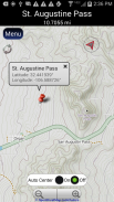
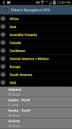
📡 北极星地点选择器。查找远足径、露营地等等!
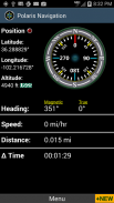
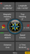
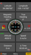
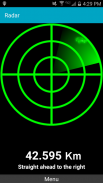
📡 GPS 罗盘和磁罗盘。
📡 GPS 信息面板。
📡 里程表、高度计、速度计、计时器。
📡 轨道上的分段距离。
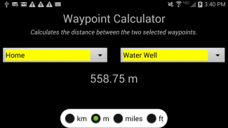
📡 连接您的航点并导航它们定义的轨道。
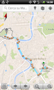
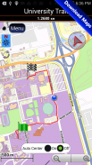
地图类型:
- 谷歌地图
- OpenStreetMap-Mapnik
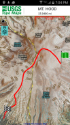
- 地形图
- 自行车路线和远足地图
- 矢量地图
- 美国地质调查局拓扑
- NOAA 海图
- 航空运营图
- 加拿大地形图
📡 全套 GPS 工具和诊断。
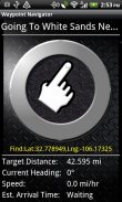
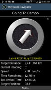
📡 航路点导航系统,包括一个动态航路点查找指南针,它始终指向您的目的地,同时报告预计到达时间、目标距离和其他统计数据。跟着箭头走!
📡 步道导航系统
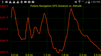
📡 海拔资料
📡位置分享
📡 支持英国 OSGR 和 OSGB-36 DATUM(军械测量网格)。
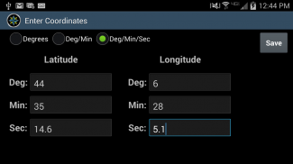
📡 坐标格式:以度为单位的纬度/经度、deg:min、deg:min:sec 和 UTM(Universal Transverse Mercator)
📡 军事坐标查找器 - 军事网格坐标参考系统 (MGRS)
📡 远足径 - 大多数地图都显示由 Openstreetmap 项目提供的远足径。您会发现在我们的地图上甚至可以看到一些最偏远的远足路线。
⚓ 航海 - NOAA 航海图和航海单位报告。
⚓ 漂移警报/拖锚警报。
📡 选择高度报告来源:卫星、美国地质调查局或将您的位置映射到 NASA 航天飞机雷达地形测量任务的结果。
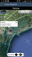
📡 标有坐标的航点照片。
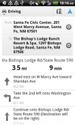
📡 道路导航和街道方向通过数字管道提供,将 Polaris 的强大功能连接到您设备上的 Google 地图应用程序。
。
Polaris GPS Navigation - 版本9.25
(30-01-2024)
Polaris GPS Navigation - APK信息
APK版本: 9.25程序包: com.discipleskies.android.polarisnavigationPolaris GPS Navigation的最新版本
其他版本


同类应用


